|
 |
| |
|
| |
PIRI REIS - A CARTOGRAPHER AT HEART

|
| |
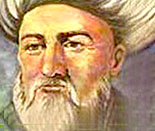
Piri Reis will be forever linked with cartography
because of the historical map which bears his name.
Piri Reis was born Hadji Muhiddin Piri Ibn Hadji Mehmed around 1465
in Gallipoli of the Ottoman Empire. Young Piri joined his uncle,
Kemal Reis, as a privateer harassing and plundering the ships of
enemies of the Ottoman Empire. Yavuz Sultan Selim extended an
invitation to them to join the Ottoman Navy as reis or admirals.
Kemal Reis died in 1510.
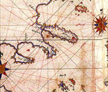
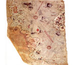
Piri Reis was a cartographer at heart. In 1513, he rendered the
world map which bears his name. Only half, the part detailing South
America’s east and Africa’s west coasts, exists today. That section
on gazelle skin is approximately 35 inches by 25 inches. Piri Reis
did not survey the lands himself. Instead, he used 28 charts and
maps including eight from the time of Ptolemy (300 BC or earlier)
and a copy of the map of Christopher Columbus’ exploration of the
New World.
Piri Reis standardized the various map scales and drew an
amazingly accurate map with 30 hand-written inscriptions. Piri Reis
presented the completed project to Sultan Suleiman the Magnificent
in 1517.
|
 |
|
| |
|
|
| |
 |
|
| |
|
|
| |
He compiled his detailed navigational maps of the Mediterranean Sea
and coastlines into his Kitab-i Bahriye (Book of Navigation) in
1521. His charts include Anatolia, the region between the Black and
the Mediterranean Sea, where his uncle’s father was born. In 1526,
Piri Reis presented Sultan Suleiman a revised copy of the Kitab-i
Bahriye.
Piri Reis drew up a second world map in 1528. The existing fragment
shows modern day Greenland, North America from Labrador to Florida,
Cuba, and some of Central America. In his later years, Piri Reis
became Chief Admiral of the Navy.
Then Egyptian officials accused him of fleeing from the Portuguese
during a battle to save himself and his fortunes. The Sultan had
Piri Reis beheaded and all his possessions stored at Topkapi
Palace (Topkapı Sarayı) in Istanbul.
While the Palace was being restored in 1929, the map fragments were
found. They are preserved in Topkapi Palace’s Imperial Library out
of public view. |
 |
|
| |
|
|
| |
 |
|
| |
|
|
<-Back |
|
|
 |
|